I was directed towards this concept by my tutor Andy Hughes to help me with my assignment, “Square Mile”.
Berger is Associate Professor of Landscape Architecture at Harvard, and introduced the term “drosscape” to describe waste landscapes around urban areas (Berger 1998). He defines it as “a term to describe a design pedagogy that emphasises the production, integration and re-use of waste landscape throughout the urban world.” He suggests that processes such as de-industrialisation and technological innovation lead to waste landscapes, as structures and areas are no longer used. The processes leading to this include rapid horizontal urbanisation, as cities extend into the surrounding areas; and the creation of left-over development of previous economic regimes.
As such, Berger suggests that drosscapes are a natural component of very dynamically evolving city, and reflect healthy urban growth. He approaches these landscapes from the perspective of an urban designer and advocates that designers adapt their role to incorporate these changes into new urban design.
Although they might be considered visually unattractive, Berger suggests that they are neither intrinsically bad or good, merely an inevitable consequence of urban and technological change.
Images of Drosscapes
Berger’s book is illustrated with examples from aerial photographs, serving to document the variety of waste landscapes. The areas he studies are exclusively in the USA.
I have searched for photographers who have used images of drosscape.
Katherine Westerhout has an extensive catalogue of images of derelict buildings of various types, in the USA. Her work concentrates on the buildings themselves and the how the process of decay and degeneration affects the fabric of the building. This is exemplified by work such as Yonkers Power Station II (Westerhout, 2011).

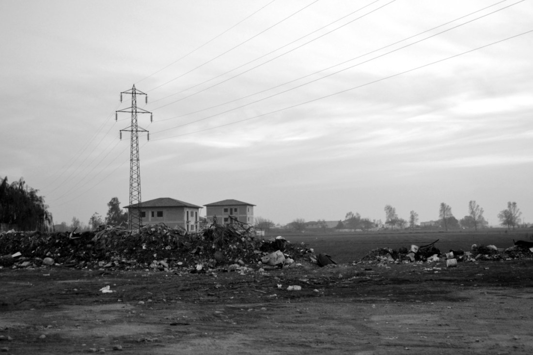
Fortuna D’Angelo uses black and white imagery to depicit drosscape in Italy in his image, Drosscape by the periphery of Naples. Casal di Principe (Italy), (D’Angelo, 2011). This image shows the derelict area adjacent to new development and rural areas.
Relevance to my work – Square Mile
The classic description of drosscape refers to waste land around American cities, by the process of “rapid horizontal urbanisation”. As such that process relies on there being land around the city to allow new development into. This is not the case in the UK, particularly around Glossop.
However if I consider the process rather than the physical manifestation of it, there has been changing land use for centuries in my study area. It is this change that I aim to illustrate, even if there are not drosscapes of the type described by Berger.
The images of Westerhout, show the buildings, and their decay. They show the effect of the process of decay and as such reflect a static image of one point in the building’s history. They do not put the building into its context and surroundings. I hope to show in my images a reflection of the process of both decay and regeneration as part of the cycle of a dynamically evolving city, which in turn in Berger’s words “reflect healthy urban growth”.
This latter aspect is more in keeping with the image of D’Angelo – showing several stages of the cycle.
References:
Berger A (1998) Drosscapes: Wasting Landscape in Urban America. Princeton University Press.
D’Angelo F (2011) Drosscape by the periphery of Naples. Casal di Principe (Italy), 2011. https://fortunadangelo.tumblr.com/
Westerhout K (2011) The East & South; The Catskills/Yonkers. http://www.katwest.com/gallery_the_catskills_yonkers.html

2 thoughts on “Drosscapes”